


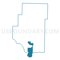
Galla Out Voting District, Pope County, Arkansas
About
Outline

Summary
| Unique Area Identifier | 527759 |
| Name | Galla Out Voting District |
| County | Pope County |
| State | Arkansas |
| Area (square miles) | 32.45 |
| Land Area (square miles) | 30.76 |
| Water Area (square miles) | 1.69 |
| % of Land Area | 94.80 |
| % of Water Area | 5.20 |
| Latitude of the Internal Point | 35.19465260 |
| Longtitude of the Internal Point | -93.05280900 |
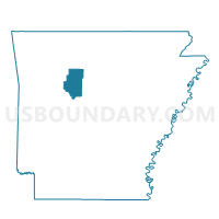
Maps

Graphs
Select a template below for downloading or customizing gragh for Galla Out Voting District, Pope County, Arkansas


Neighbors
Neighoring Voting District (by Name) Neighboring Voting District on the Map
- Dardanelle Out Voting District, Yell County, AR
- Galla Rock Voting District, Yell County, AR
- Gumlog Voting District, Pope County, AR
- Illinois NOE Voting District, Pope County, AR
- Illinois SOE Voting District, Pope County, AR
- Pottsville Galla 1 Voting District, Pope County, AR
- Pottsville Galla 2 Voting District, Pope County, AR
- Pottsville Galla 3 Voting District, Pope County, AR
- Russelville 3B Voting District, Pope County, AR
- Russelville 3C Voting District, Pope County, AR
- Valley 2 Voting District, Pope County, AR
- Wilson Out West Voting District, Pope County, AR
Top 10 Neighboring County Subdivision (by Population) Neighboring County Subdivision on the Map
- Illinois township, Pope County, AR (29,813)
- Dardanelle township, Yell County, AR (7,992)
- Wilson township, Pope County, AR (4,774)
- Galla township, Pope County, AR (4,681)
- Valley township, Pope County, AR (3,258)
- Gum Log township, Pope County, AR (1,717)
- Galla Rock township, Yell County, AR (321)
Top 10 Neighboring Place (by Population) Neighboring Place on the Map
Top 10 Neighboring Unified School District (by Population) Neighboring Unified School District on the Map
- Russellville Schools, AR (37,630)
- Dardanelle Public Schools, AR (10,415)
- Pottsville Public Schools, AR (5,737)
Top 10 Neighboring State Legislative District Lower Chamber (by Population) Neighboring State Legislative District Lower Chamber on the Map
- State House District 68, AR (32,119)
- State House District 61, AR (29,993)
- State House District 70, AR (29,754)
Top 10 Neighboring State Legislative District Upper Chamber (by Population) Neighboring State Legislative District Upper Chamber on the Map
Top 10 Neighboring 111th Congressional District (by Population) Neighboring 111th Congressional District on the Map
Top 10 Neighboring Census Tract (by Population) Neighboring Census Tract on the Map
- Census Tract 9512, Pope County, AR (8,437)
- Census Tract 9516, Pope County, AR (7,166)
- Census Tract 9523.01, Yell County, AR (3,126)